
Colorado has more Nationally designated America’s Scenic Byways than any other state in the Nation.
Since I’m here in Colorado visiting my Pop, I think should check as many of them out as I can.
Pop and I had done the Peak to Peak Scenic Byway and Trail Ridge Road Scenic Byway a few weeks ago.
And we drive on the Lariat Loop Scenic Byway at least once a week.
I had been to the top of Independence Pass before in my old Blazer.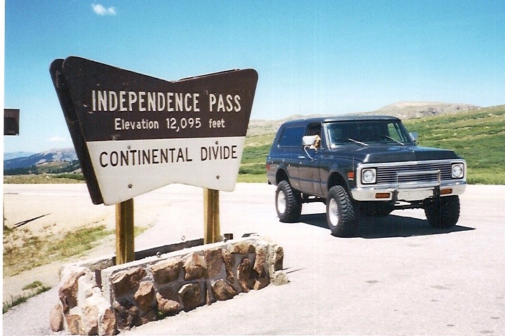
But I hadn’t been up to the top in The 55.
Yet…
Independence Pass at 12,095 feet was the highest paved crossing of the Continental Divide in the United States up until a few years ago when they paved the other side of Cottonwood Pass at 12,126 feet.
The Top of the Rockies Scenic Byway just so happens to include Independence Pass.
Pop & I got onto I-70 and headed west.
At exit 241A we made our way into Idaho Springs passing the 6&40 Motel to our right.
I love exploring all the old buildings in Idaho Springs – there’s so much history.
In my guesstimate – there are more buildings that have historical significance and are over 100 years old than aren’t.
Like the Idaho Springs Public Library – built in 1904 – it’s one of the few remaining original Carnegie Libraries.
It’s right out there in the open and hasn’t changed much in over 100 years.
And just down the street from the library is a fully operational “Batwing” gas station.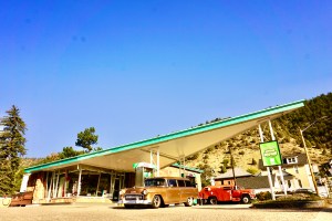 These “Batwing” stations were designed by Clarence Reinhardt who was an architect at Phillips Petroleum and I just love ’em!
We got back on I-70 and headed west towards the Eisenhower / Johnson Tunnels.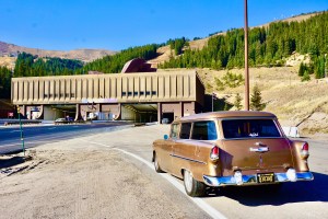
If you live in Colorado you pretty much take these tunnels for granted.
But they’re pretty incredible.
They are the highest tunnels in the United States.
They’re also the longest mountain tunnels and the highest point on the United States Interstate Highway System.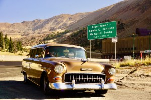
We got back on I-70 and kept on heading west towards Vail.
We passed Copper Mountain and went up Vail Pass – which is no big deal at only 10,666 feet above sea level.
We’d already been up and over Eisenhower Pass at 11,158 feet.
A few miles west of Vail we turned off at the US-6, CO-24, Minturn exit – one of the starting points of the Top of the Rockies Scenic Byway.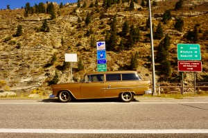
We could’ve turned off of I-70 at Copper Mountain and taken CO-91 into Leadville, but then we’d have missed the town of Red Cliff.
And the Red Cliff Truss Bridge.
It’s like California’s Bixby Bridge.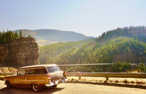
It’s also listed on the National Register of Historic Places.
Just before the bridge we turned left into Red Cliff.
It’s a short, narrow, windy road down into the little town of Red Cliff.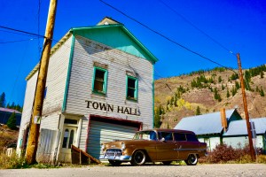
But it’s so cool.
The Red Cliff Town Hall kind of reminds me of the Squirrel Dance Hall Community Club in Idaho.
And the Red Cliff Post Office.
I’ve got a thing for Post Offices for some odd reason.
We drove back up the narrow little road and made a left across the Red Cliff Truss Bridge.
After a few miles we came to Tennessee Pass at 10,423 feet above sea level.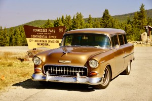
Our second crossing of the Continental Divide of the day and it wasn’t even noon.
This is the area where the 10th Mountain Division trained in the snow for World War II.
We continued on into Leadville.
Denver is the Mile-High City at 5280 feet above sea level.
They call Leadville the Two-Mile-High City because it’s 10,152 feet above sea level.
In Colorado you can tell if it’s a legitimate place to check out if there’s a “Historic” in front of the town name.
And Historic Downtown Leadville did not disappoint.
The Tabor Opera House was built in 1879 and at the time was the most expensive structure in the state of Colorado.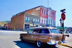
It was built by Horace Tabor, who was one of the founders of Leadville, a US Senator, and – at the time – the richest man in Colorado.
We drove thru Leadville and continued on the Top of the Rockies Scenic Byway.
Leadville is also known for having multiple fourteen thousand foot mountains – “fourteeners” – viewable from town. 
Then we got a sign.
Literally – the sign reading Independence Pass was open!
Nice.
We followed the Arkansas River on CO-24 towards the town of Twin Lakes.
At the intersection of CO-82 we made a right.
After a few miles we saw the speed limit sign change to 45mph to 35mph to 25mph.
Uh-oh.
As we rounded the corner into Twin Lakes there was a white Ford Crown Victoria with a mannequin dressed up as a police officer sitting inside.
A 100-yards away – on the other side of town – was a white Ford Bronco with another mannequin dressed up as a police officer inside.
Welcome to the Colorado small town speed-trap.
That’s how a lot of small towns make money – speed traps.
After evading the fake police – Faux-Po – we started up Independence Pass.
As luck would have it there were three slower cars in front of us.
All from out of state and all doing well below the posted speed limit.
And none of them willing to pull over and let us pass.
So we were forced to slow down and enjoy the sights as we crawled our way up to the top of the Continental Divide.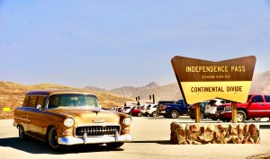
This would be our third crossing of the Continental Divide today.
Pop and I had a sandwich at the summit to celebrate.
We didn’t need to go down into Aspen – we went back down into Twin Lakes
Fall in Colorado is beautiful.
We were lucky enough to catch the aspens changing colors.
Back at the intersection of CO-82 we decided that instead of making a left and head back into Leadville, we would go right and head towards Buena Vista and check out the Collegiate Peaks Scenic Byway.
I couldn’t resist the two-for-one Scenic Byway signage.
We meandered along the Collegiate Peaks Scenic Byway thru Granite and into Buena Vista where we made a left onto 24 / 285 towards Fairplay.
I remember the town of Fairplay because we’d always stop at the historic Fairplay Hotel on our way to go skiing when I was a kid.
They had the best cinnamon rolls ever.
It is an old, creaky Hotel and we always loved stopping in for a bite to eat on our way up to the mountains.
Now the historic Fairplay Hotel is blue and is used for employee housing.
So sad.
But we found this Hotel a block over on Front Street.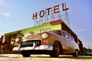
In all the times I’ve been thru Fairplay, this was the farthest away from Highway-9 I had ever been.
From Fairplay we got back onto 285 and headed towards Baily.
On our way we drove past Grant – the start of the Guanella Pass Scenic Byway.
In case you’re wondering – the Hot Dog stand was still closed.
I asked Pop if he was interested in having a beverage at the Bucksnort Saloon and he was all in.
We made a right at the light and onto Pine Valley Road.
At Pine Grove we made a left onto Elk Ridge road which would take us to the Bucksnort Saloon.
Elk Ridge Road is a two-way, dirt road that’s only a lane and a half wide.
After a Bucksnort Burger and beer we were back on the road.
We headed up Elk Creek Road and got back on 285 towards Conifer.
That’s where we got on CO-73 to go back into Evergreen.
Once we were through the stop-light in downtown Evergreen we were back on the Lariat Loop Scenic Byway to Pop’s place.
But not before being confronted by the King of the Road.
This guy was there standing in the middle of the road.
Minding his own business.
Without a care in the world.
I think he wanted to check out The 55.
A few days after this we read that a local golfer was gored by a bull-elk.
These guys don’t play around.
All in all Pop and I drove over 300 miles, crossed the Continental Divide three times and drove on two National Scenic Byways and one State Scenic Byway.
Not too bad for a 65 year old station wagon right?
Thanks for coming along for the ride with us!
Next time – I hope to see you out on the road.
#idrivea55
